
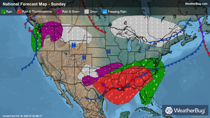
Much of the South will have to enjoy Super Bowl Sunday inside as widespread rain and thunderstorms occupy the region, while most other folks around the country can enjoy some dry, tranquil weather to close out the weekend.
A cold front will slowly drift across the Southeast Sunday. A strengthening low-pressure system will be following not too far behind this cold front in eastern Texas, moving through the Deep South by nightfall.
Frequent rain showers and thunderstorms will be in the forecast for most of Texas and eastern Oklahoma into the Deep South, Southeast, and Mid-Atlantic throughout the day. Repeated rounds of moderate to heavy rain will continue to be a concern, especially along the Gulf Coast. There will also be a chance for strong to severe thunderstorms. The main threats would be damaging winds and a few tornadoes, but some large hail cannot be ruled out.
Temperatures will be noticeably colder across eastern Colorado, western Kansas and New Mexico into the Texas and Oklahoma panhandles. Here, precipitation will fall in the form of snow. There will be a period of heavy to very heavy snow across the Texas and Oklahoma panhandles starting mid to late morning and continuing into the early evening. Otherwise, expect mainly light to moderate snowfall. Accumulation will be greatest in the Texas Panhandle, where some areas may see up to a foot of snow.
Dangerous to near impossible travel conditions will be likely in areas that see heavy to very heavy snow. This will be due to snowy, icy roads and lowered visibility both due to high snowfall rates and blowing snow. Any other areas that see snow for the end of the weekend could also deal with some travel concerns.
A new Pacific storm system will crash into the Northwest on Sunday. Rain will soak the coast and lower elevations of the Pacific Northwest throughout the day, while snow falls in the mountains and higher elevations. Light snow could also spread to the northern Rockies in the afternoon and evening.
Expect a quiet day of weather across California and the Great Basin thanks to high pressure overhead. It should also stay dry across the northern Plains, Upper Mississippi Valley, Great Lakes and Northeast.
Temperature wise, much of the Eastern and Central U.S. stays slightly above average, while the West remains below average. There will be teens in the highest elevations of the Rockies, with 20s, 30s and 40s for the rest of the Mountain West, most of the Plains, Midwest, Great Lakes and Northeast. The West Coast and the Southwest into the southern Plains, Deep South, Southeast and Mid-Atlantic will experience 50s, 60s and 70s. A few spots in Florida could also see the mercury climb into the 80s!


