By WeatherBug's Domenic Brooks
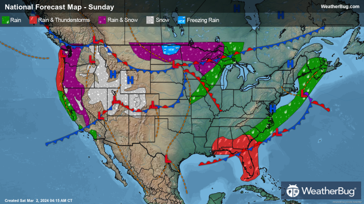
The Western U.S. will continue to be under the influence of a large storm system for the conclusion of the weekend. A low-pressure system will also develop ahead of this storm system, which will move across the north-central U.S. Precipitation will be in the forecast throughout the West Coast, Great Basin, and north/central Rockies as well as the northern Plains and Upper Mississippi Valley as a result.
Like Saturday, precipitation will remain in the form of rain along the immediate West Coast, California, and even western/northern portions of the Southwest. However, snow or mixed showers will be possible for western Washington and western Oregon early today. Expect light to moderate snow from the Cascades and Sierra Nevada into the northern/central Rockies, possibly becoming heavy at times.
Things will get more complicated for the Front Range and northern/central Plains and Upper Mississippi Valley. Rain could initially develop across the eastern Dakotas, Minnesota, and Iowa, which could then mix with and change over to snow by this evening. Eastern Montana, eastern Wyoming, western Nebraska, and the western Dakotas will mainly see just snow, but some freezing rain could mix in at times.
Saturday’s low-pressure system will drift across the coast of southern New England, with a new system forming along the tail end of the stalled cold front along the Gulf Coast. These two systems will likely lead to drizzle or light showers along the coast of New England, the Southeast, and for areas along the Gulf Coast. The best timing would be this morning and afternoon along the East Coast, then this afternoon and evening for the Gulf Coast.
A few spots will stay out of the unsettled weather today, including the southern Plains, Mid-Mississippi Valley, Great Lakes, and Midwest.
High temperatures will remain similar to that of Saturday's, with temperatures in the teens, 20s and lower 30s for the Mountain West. A few spots could even remain in the single digits. Otherwise, expect 30s and 40s for the rest of Northwest, the northern half of the Plains and interior Northeast. California will mainly see 50s and 60s as will the Great Lakes, Ohio Valley, southern New England and Mid-Atlantic. Widespread 70s will occur in the southern half of the Plains, most of the Mississippi Valley, Midwest, Deep South and Southeast, with 80s possible in Texas and Florida.


