Susanne Rust, Brittny Mejia and Liam Dillon, Los Angeles Times on Mar 11, 2023
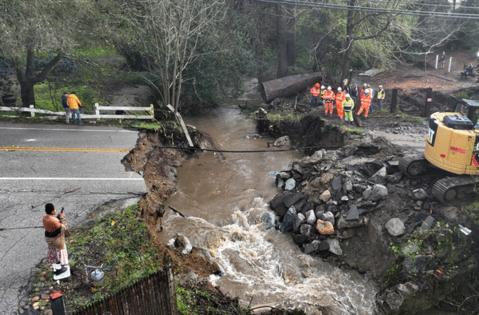
LOS ANGELES — After atmospheric river storms pummeled large swaths of California, triggering massive flooding and prompting widespread evacuation orders from the Central Coast to the southern Sierra, forecasters warned Saturday “we’re not through this just yet.”
Flash flood warnings remain in effect for parts of Santa Cruz, Monterey, Tulare and Sonoma counties, according to the National Weather Service. Major flooding was reported in the Tulare County’s Springville area — where officials conducted dozens of water rescues Friday morning — and in Kernville, where the roaring Kern River surrounded some houses and mobile homes, spurring evacuations.
The chief concern is the threat of thunderstorms in the afternoon, said Gerald Meadows, a meteorologist with the National Weather Service in Hanford. The greatest risk, he said, is from the southern edge of Tulare County and northern edge of Kern County, all the way north through the San Joaquin Valley.
“We can see winds in excess of 45 miles an hour gusts out of any thunderstorm or increased rainfall potential,” Meadows said. “It’s just going to exacerbate any flooding issues that we’re already seeing.”
A tenth to a quarter of an inch of rain is expected in the valley, with a quarter inch to a half inch of precipitation in the Sierra Foothills and higher terrain, according to Meadows.
In Monterey County, a levee along the Pajaro River — three miles upstream from the town of Pajaro — breached late Friday night, according to Nicholas Pasculli, a county spokesperson.
He said patrols had noticed boils “bubbling up in the adjacent farmland” at 11 p.m. “That was the first sign that there was an issue,” he said.
Thirty minutes later, the levee failed. “It was a small section initially, but as of this morning the failure is approximately 100 feet wide,” he said.
He said the Monterey County Sheriff’s Office, in conjunction with the Watsonville Police department and California Highway Patrol, did a second round of evacuation notices at around 11:30 p.m. Friday.
Although they had done one earlier in the day — at 3 p.m. — many residents had stayed put. “So we went back and made sure we stayed there until we were able to get people safely out and into shelters,” he said.
More rain is on the way, forecasters warned.
Although the bulk of precipitation fell in the last 36 hours, Meadows said Saturday morning, “we do have another event on the horizon coming in early next week that’s going to bring in a considerable amount of precipitation.”
While it won’t be as much as the one that moved through Friday, he said, “with a little bit higher snow levels or snow melt range expected we can see as much, if not more, flooding impacts.”
“One of the big messages we want to get across for the folks in the San Joaquin Valley especially, as well as the Sierra foothills, is though it’s clearing up and it’s not raining very hard right now, we’re not through this just yet,” Meadows said. “The impacts are going to increase and the thunderstorms can change the situation pretty rapidly.”
©2023 Los Angeles Times. Visit at latimes.com. Distributed by Tribune Content Agency, LLC.


